
Beith: Difference between revisions
Rosser1954 (talk | contribs) |
Rosser1954 (talk | contribs) |
||
| Line 105: | Line 105: | ||
Image:Barony of Giffen arms.JPG|<Center>Detail of the Coat of arms of the Barony of Giffen from the Auld Kirk, now in the Beith Kirk built in 1807. |
Image:Barony of Giffen arms.JPG|<Center>Detail of the Coat of arms of the Barony of Giffen from the Auld Kirk, now in the Beith Kirk built in 1807. |
||
Image:Barony of Giffen coat of arms.JPG|<Center>The Barony of Giffen coat of arms. |
Image:Barony of Giffen coat of arms.JPG|<Center>The Barony of Giffen coat of arms. |
||
Image:Giffen aisle at Beith Auld Kirk.JPG|<center>The old Giffen aisle at Beith Auld Kirk. |
|||
</Gallery> |
</Gallery> |
||
Revision as of 21:31, 6 September 2008
| Beith | |
|---|---|
| Population | Expression error: "6,346[1] (2001 census) est. 6,210[2] (2006)" must be numeric |
| OS grid reference | NS349542 |
| Council area | |
| Lieutenancy area | |
| Country | Scotland |
| Sovereign state | United Kingdom |
| Post town | BEITH |
| Postcode district | KA15 |
| Dialling code | 01505 |
| Police | Scotland |
| Fire | Scottish |
| Ambulance | Scottish |
| UK Parliament | |
| Scottish Parliament | |

Beith is a town in North Ayrshire, Scotland.
One of its various claims to fame is that a signatory of the American Declaration of Independence, the Rev. John Witherspoon, was a former minister of its parish.
The sixteenth century poet Alexander Montgomerie was born in Hazelhead Castle, which is on the outskirts of Beith.
Dr Henry Faulds, the originator of the forensic use of fingerprinting as a means to identify criminals, was born in Beith in 1843.
It was also home to many world-famous cabinet works, such as Stevenson and Higgins.
The town was once served by two railway stations: Beith North and Beith Town. Both these stations are now closed, with the nearest station now being Glengarnock.
Beith also has its own golf course (the 8th hardest amateur course in Britain), two Beith Parish Churches of the Church of Scotland, 102nd Scout Group, and modern Primary school. The Royal Navy also maintains an armament depot, DM Beith, in the area.
Beith Rocking Stone

The Beith Rocking Stone, weighing 11 tons, sits on top of Cuff Hill. Local Folklore states that the Rock once upon a time rocked from side to side on a balance point.
The Beith Moot Hill


The 'Court Hill' is near Hill of Beith, Gateside, in the Barony of Beith. Dobie states that this is the Moot Hill on which the Abbot of Kilwinning used to administer justice to his vassals & tenants. It is a sub-oval, flat-topped mound, measuring 15.0 by 14.5 metres (49.2 x 47.6 ft) over all, 10.0 by 8.0 metres (32.8 x 26.25 ft) across the top, and 2.0 m (6.6 ft) high, situated at the foot of a small valley. A number of large stones are visible in the sides of the mound. It is turf-covered, and probably situated on a low outcrop, it is mostly an artificial work. It pre-dates the channelling of the burn which detours around it, the mound was probably isolated in this once marshy outflow of the former Boghall Loch (see NS35SE 14).[3]
The Court Hill gallery
-

The Court Hill from the field above. -

The view from below the moot hill. -

Details of the hill and the deeply excavated Boghall Burn. -

Details of the boulders used in the construction of the Court hill.


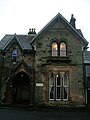
Speir's school
This school stood on the Barmill Road near the old Marshalland Farm. It was built Mrs Margaret Speir of the Marshalland and Cuff estate in 1887 to commemorate John Speir, her son, who had died at the tender age of 28. The school started as a fee paying day and boarding school, becoming part of the county education system in 1937. Following the construction of Garnock Academy, Speir's school closed in 1973 and the buildings were demolished in 1984.
The 16 acres of woodland and gardens remain a popular site for dog walkers, bird watchers, and those out to enjoy the rural surroundings.
Spier's School grounds gallery 2007 - 2008
-

The terraced lawn and garden beside the old walled garden area. These were tennis courts at one time. -
A view from near the Barrmill Road tradesman's entrance up towards the old school buildings. -

Looking down towards Barrmill Road from the old school site. -

Scots pine and old plantings in front of the old school site. -

The woodland policies near the Barrmill Road. -

Looking towards the Powgree burn near Geilsland Road. -

Looking towards Barrmill Road from near Geilsland Road. -

Ivy dominated woodland near Geilsland school.


Geilsland
William Fulton Love, writer and bank agent in Beith, built this small estate near Gateside in the 19th-century although the deeds go back to the 17th-century.[4] Geilsland is a special school, run by the Church of Scotland.[5]. It is separated from the Speir's school grounds by the Geilsland Road.
Geilsland House and School gallery
-
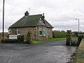
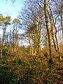
Geilsland Lodge and main entrance. -
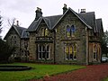
A view of the side of the house which faces Beith. -
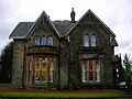
The side of the house which faces Geilsland Road and Speir's school grounds. -
The main entrance to Geilsland House.


Beith Auld Kirk gallery
-
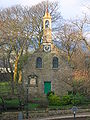
Beith Auld kirk. -

The Old Sundial dated 1841. -

A memorial stone inside the old kirk. -

Detail of the 'Agnus Dei' on the John Speir Memorial. -

The John Speir memorial, previously at Speir's school. -

Detail of the John Speir memorial. -

The memorial to John Speir's wife. -

The other John Speir memorial from Speir's school.


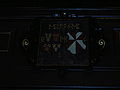
Beith kirk gallery
-

Commemorative plaque in Beith Kirk. -
Detail of the Coat of arms of the Barony of Giffen from the Auld Kirk, now in the Beith Kirk built in 1807. -

The Barony of Giffen coat of arms. -

The old Giffen aisle at Beith Auld Kirk.


See also
References
- ^ "Comparative Population Profile: Beith Locality". Scotland's Census Results Online. 2001-04-29. Retrieved 2008-08-31.
- ^ http://www.gro-scotland.gov.uk/statistics/publications-and-data
- ^ RCAHMS Canmore archaeology site
- ^ Dobie, James (1876). Cuninghame topographised by Timothy Pont. Pub. J.Tweed. Edinburgh. P. 214.
- ^ Geilsland school
External links
This North Ayrshire location article is a stub. You can help Wikipedia by expanding it. |